The National Weather Service indicates a chance for light snow showers across New Hampshire on Christmas Day, originating from a distinct weather system separate from the significant Christmas Eve snowfall event.
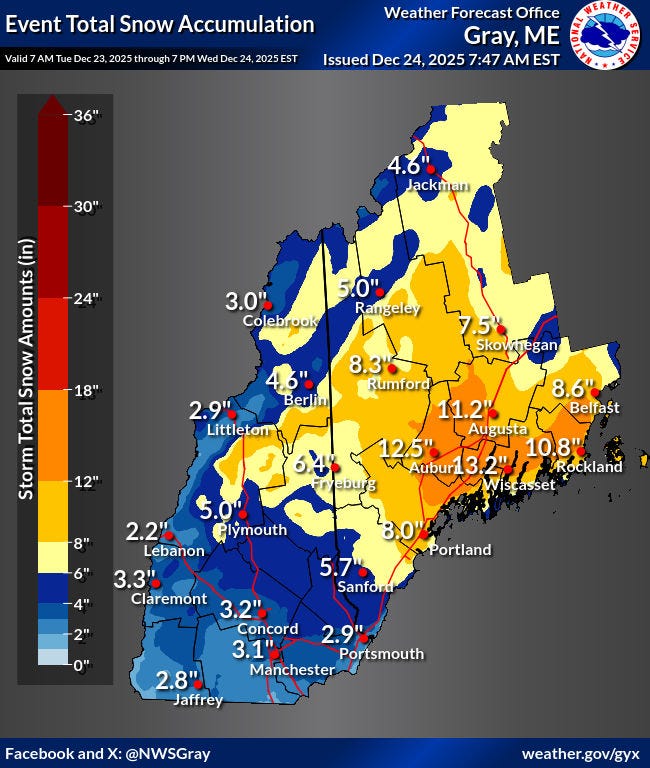
A winter storm warning remains active through Wednesday afternoon, December 23, as the earlier storm continues to impact the region. Forecasters predict this system will deposit approximately 3 inches of snow in the Portsmouth area before tapering off in the early afternoon.
The anticipated Christmas Day precipitation involves a different atmospheric pattern. "A strong cold front crosses on Christmas bringing chances for snow showers and gusty NW winds Thursday night," stated the forecaster's discussion. "Clouds will increase overnight with a few snow showers possible towards dawn."
Focus on Current Storm Impacts
With only light accumulation expected for Christmas, attention remains on the ongoing Christmas Eve storm's effects. Projections suggest Rochester could see accumulations nearing 4 inches.
An advisory from the National Weather Service warns: "The potential exists for snowbands that will bring periods of locally heavy snowfall, which will lead to rapid snow accumulations and extremely dangerous travel conditions. Periods of moderate and heavy snow will combine with low visibility to create dangerous driving conditions. The hazardous conditions could impact the Wednesday morning commute as well as holiday travel."
Weather Alerts and Preparedness
Residents are advised to monitor official weather alerts and prepare for potentially hazardous travel conditions through the holiday period.