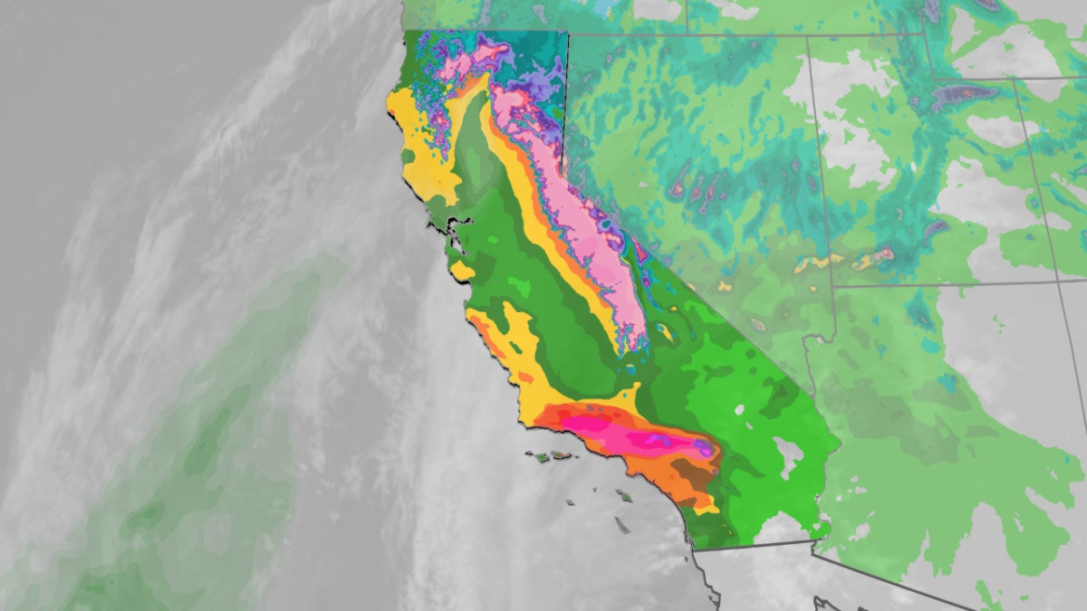
California is bracing for severe weather conditions as multiple atmospheric rivers approach the state during the Christmas holiday period. Meteorologists have expressed particular concern about the potential for flash flooding and landslides.
Unusual Warning Level
The National Oceanic and Atmospheric Administration's Weather Prediction Center has issued an uncommon "high risk" alert for sections of Southern California, specifically for Wednesday and Wednesday night. According to NOAA/WPC, such high risk forecasts are only declared on approximately 4% of days, yet they are responsible for 36% of all flood fatalities and 80% of flood-related damage across the United States.
Storm Schedule
Tuesday night through Christmas Eve: A powerful storm system will arrive in California, bringing intense rainfall and strong winds. Northern California will experience the initial impact Tuesday night, followed by Southern California overnight, with heavy precipitation continuing into Wednesday. The Desert Southwest, including areas like Las Vegas and possibly Phoenix, may also see locally heavy rain during this period.
Christmas Day through Friday: A second significant Pacific storm is expected to reach California on Christmas Day, delivering another round of heavy rain, strong winds, and substantial Sierra snowfall. Showers and mountain snow will persist into Friday, with some locally heavy activity possible in parts of the Desert Southwest on both days.
Weekend: While scattered showers might remain in the Four Corners region on Saturday, California and the broader Desert Southwest are forecast to dry out once again.
Expected Precipitation
Northern California: Widespread additional rainfall totals exceeding 3 inches are anticipated through Friday, with localized amounts surpassing 5 inches in coastal ranges and foothills of the northern and central Sierra below snow level. The Bay Area could receive another 1 to 5 inches, equivalent to about a month's typical rainfall for San Francisco.
Southern California: The Los Angeles Basin, stretching from Santa Barbara to Orange County, is projected to accumulate at least 3 inches of total rain during the Christmas week storms. Higher totals are likely in Southland mountains below snow level, where some areas may see over 8 inches, especially on south-facing slopes and foothills. San Diego County may also gather at least 2 inches. The heaviest rainfall for the region, with rates possibly exceeding an inch per hour, is expected Wednesday and Wednesday night, then again Thursday afternoon and night.
Mountain snow: Several feet of Sierra snow are forecast from Tuesday night through Friday. This snowfall is critically needed as the California snowpack is currently significantly behind schedule.
Potential Consequences
The heavy rain is likely to trigger flash flooding and landslides, particularly in hilly and mountainous terrain and areas recently affected by wildfires. Residents near burned zones should be prepared to evacuate immediately. Long-duration flood watches are currently in effect for much of California.
During these atmospheric river events, rain may fall at higher elevations than usual, potentially melting existing snowpack and adding to the threat of flash and river flooding.
Strong winds accompanying the Pacific storms starting Tuesday night could topple trees and cause power outages, especially in areas where the ground is already saturated.
The threat of localized flooding rain will also extend into the Desert Southwest, where flood watches are active. Expect localized urban flash flooding with water flowing in normally dry washes and arroyos, including the Vegas Valley.
Recent Weather Activity
The most recent atmospheric river deposited between 3 and 14 inches of rain in Northern California's coastal ranges and Sierra foothills from last Saturday night through Monday.
This led to 69 reports of flooding, 31 reports of landslides, and another 22 reports of wind damage in the state from Saturday night through Monday. Among the most serious incidents was flash flooding in and near Redding, in far Northern California, where water rescues were necessary.